
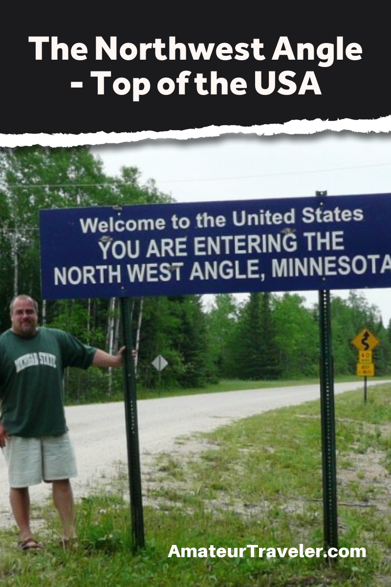
The Northernmost Spot in the 48 Contiguous U.S. States – The Northwest Angle in Minnesota
categories: USA TravelI’m a geography geek. When I was young, I would spend long driving hours on family road trips with the road atlas, pouring through the maps, looking for unique locations. When I was in High School, my geography teacher, fresh out of college and bored teaching a subject he didn’t have interest in, allowed me to teach the final few months of the school year- units on Australia and Antarctica.
It was no surprise when I went on to college and majored in Social Studies, with a concentration in Geography. When I was a teacher, I spent long hours crafting my lesson plans and designing my own worksheets, instead of using the provided textbooks. Geography has always been a big part of my life, and that has obviously translated over into my travels.
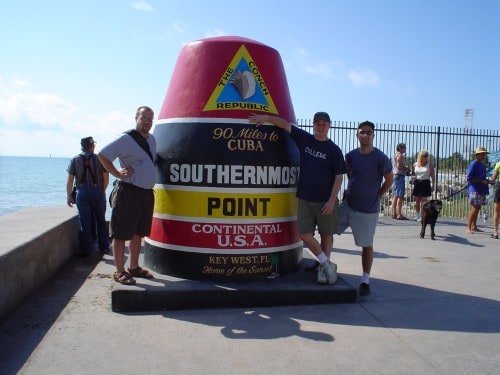
My friends & I at the Southernmost Point (Key West)
What is the southernmost point of the continental United States?
Key West, Florida is the southernmost point in the continental United States.
In January of 2003, I was visiting Key West, Florida, when we made a trip to the famous “Southernmost Point in the Continental United States” monument. That got my already geographically-obsessed mind going. I wondered how hard it would be to visit the other extreme points in the continental U.S. I had already made up my mind to attempt to visit the national park units in the lower 48 states, and the more I looked at the map, it seemed easy enough to incorporate these extreme points in with that quest.
I visited the westernmost point in Washington state in 2005, followed by the easternmost point in Maine in 2008. In June of 2009, I visited the Geographic Center of the United States in Kansas. The final point, the northernmost point, was something I had planned later in that trip.
What is the northernmost point of the continental United States?
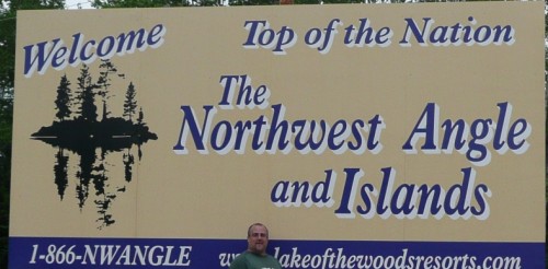
The Northwest Angle in Minnesota is the northernmost point in the continental United States. It came about because of a map-making error.
The northernmost point is a geographic anomaly. It is the only point in the continental United States that lies north of the 49th Parallel. It is technically part of Minnesota, but it is not connected to the rest of Minnesota by land. This 116 square mile section of land is only part of the United States due to an incorrect understanding of where the source of the Mississippi River was and a mistake made by the first mapmakers in the area.
The Final Extreme Point
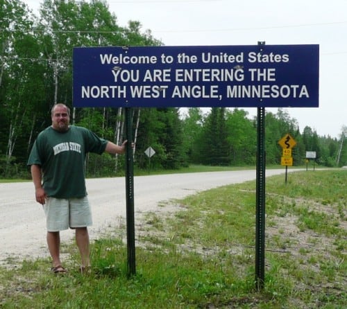
Getting to the Northwest Angle requires crossing into Canada. As I was coming from North Dakota, I entered Canada via the border crossing at Pembina, ND and drove 85 miles through the plains of Manitoba. I reached the turn-off to head north toward the ‘Angle’ on Manitoba Highway 308. I had researched getting to the Northwest Angle and did not find a lot of information, but I did know the two roads that I would be taking (308 & 525) would be unpaved. I had not read anywhere how rough these roads would be.
The section of Manitoba I had passed through had been sparsely populated farmland, but once I turned north, I entered heavy forest with only the slightest signs of settlement anywhere. The final 8 mile stretch of road (Manitoba 525) was some of the roughest road I have ever driven on. (I was later told by the nice lady at the gas station in the Northwest Angle that recent rains had made the road rougher than normal.) I expected to feel elation at collecting this final token of the geographic conquest, but the pinging of rocks from the gravel road underneath the van and the boring nature of the drive had taken a little of that enjoyment out of me.
I questioned myself further when in the five minutes it took me to set up the camera and tripod to snap my pictures, I was swarmed with mosquitos and biting flies. This shouldn’t have been a surprise- the Northwoods of Minnesota are renowned for their biting insect population- but I was still annoyed at the inconvenience.
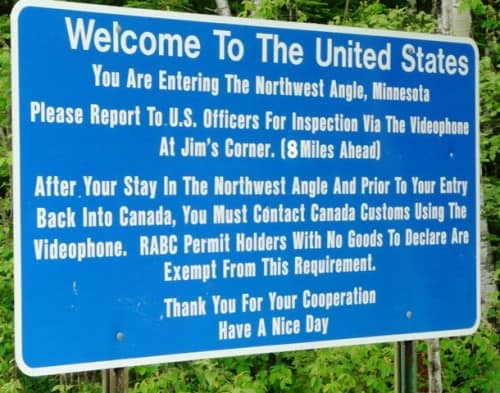
There are no formal customs booths entering the Northwest Angle. Instead, the sign shown above instructs visitors to proceed 8 miles down the road to a small shed where they will communicate via videophone with both United States and Canadian customs officers.
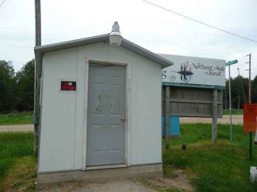
US & Canadian Customs Shed
I phoned both the county’s customs officials. The video part of the phone was not working. I read both my passport number and explained the purpose of my visit. I felt a little silly explaining this to them, but I guessed that despite avid fisherman, most of the Angle’s visitors were there for the same purpose as me.
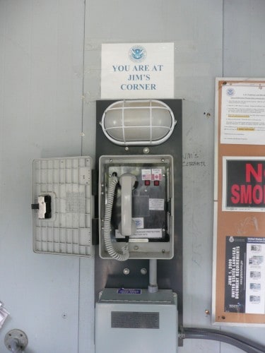
Call Box in Customs Shed
As previously mentioned, finding information about the Northwest Angle had proven difficult. I drove to the only town in the territory, Angle Inlet, which was one of the smallest settlements I have ever seen. There were a few basic businesses serving the population (116 permanent residents as of the last census). There was also a resort and golf course on the northern end of the peninsula. 70% of the Northwest Angle’s land is part of the Red Lake Indian Reservation. Many of the dwellings I saw appeared to be summer cottages.
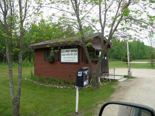
Northernmost Post Office in the Continental US
The only thing that comes close to a ‘tourist site’ in the Northwest Angle is the pint-sized Northernmost Post Office in the Continental United States. It had closed for the day at the time of my visit, so I stopped at the small gas station across the street to try and find some postcards or other small souvenirs from my visit. They didn’t have any postcards, so I settled for a tourist brochure/newspaper, which was all the nice lady behind the counter could come up with as a souvenir. I asked her how many people she saw visiting for the same obscure purpose as me.
“A few, I suppose. Most end up looking as disappointed as you do now.”
I hadn’t meant to look so downtrodden. I shouldn’t have expected much. Later, upon reflection, I was able to come up with some pride in being enough of a geek for geography that I would spend half a day of my precious vacation time traveling to such a forlorn place. As for that day, I left the store, turned the van south, and hoped I could make it paved roads before the impending rain started.
I understand it’s not a ringing endorsement for the place. It might not make it on a list of hidden gems in the United States. The woods are beautiful, and so is Lake-in-the-Woods, the large body of water that borders Minnesota, Ontario, and Manitoba. I’ve heard it is a great place for fishing and that the fall colors are beautiful. I even read that during the winter, when the lake is frozen, people are able to drive across it to get there from the rest of Minnesota. The crossing back into the United States at Warroad, Minnesota was, by far, the most unpleasant U.S./Canadian Border crossing I have ever done. They must have figured if you are crazy enough to go all that way for bragging right, you must be worth some extra scrutiny.
If you go, the closest hotels with good ratings on TripAdvisor are about 30 miles away:
- Falcon Trails Resort in Falcon Lake, Manitoba
- Crescent Beach Cottages & Motel in Whiteshell Provincial Park, Manitoba
- Can Am Inn in Warroad, Minnesota
To see the rest of my geographic extreme points, check out the article on my blog.
 Travel to the Twin Cities of Minnesota (Minneapolis) – Episode 324
 10 Best Minnesota State Parks for Camping
 Travel to the Twin Cities of Minnesota (St Paul and side trips) – Episode 325
 San Luis Obispo, California – The Happiest City in the United States?
by Erik Smith
Erik's parents fostered a love of traveling that started with long family road trips during the summer months. His first international trip was a family jaunt to Europe at age 14. Since 2003, he has been trying to visit all the National Park units in the lower 48 states, currently standing at 304 of 350 visited. In 2010, he took a one year break from his National Park quest to visit Israel (with side trips to Jordan & Egypt) for the month of May, on a tour inspired by The Amateur Traveler. His blog is at http://onmyfeetorinmymind.blogspot.com. Twitter:@eriksmithdotcom30 Responses to “The Northernmost Spot in the 48 Contiguous U.S. States – The Northwest Angle in Minnesota”
Leave a Reply
Tags: article, erik smith, minnesota


Chris
Says:September 27th, 2011 at 11:54 am
Came across your post while searching for extreme points of the US. I too have been trying to visit these places. I’ve been to Lubec and Key West and need to get to the westernmost. Where in Washington state did you visit?
As for northernmost, according to Wikipedia, Sumas, Washington is the northernmost incorporated town, and since that seems to be my pattern so far, I’d like to go there, but I haven’t been able to find out if there’s a marker there or not (for photographic evidence of course).
Nice post! Glad to see someone else is geographically obsessed as I am!
Jan Dunlap
Says:July 15th, 2012 at 1:04 pm
I was so excited to find your article and photos! We drove this same road two weeks ago on the way to our daughter’s wedding on Flag Island. I write a humorous Birder Murder Mystery series (from North Star Press, available at select stores and on Amazon.com) and want to place a future novel in this area, so I was looking for photos to remind me of the trip, and found your blog. Your comments are all interesting too. Thanks for recording your trip!
Gary Hager
Says:August 27th, 2012 at 6:39 pm
Thank you for sharing your journey. This coming January I have a meeting in Florida and thought about doing the same thing, except start at the Northwest Angle on a snowmobile, crossing The Lake of the Woods, then drive the remainder of the way to Key West. This is not so much of a trial as I live in northern Minnesota, about 4 hours from The Lake of the Woods. Ya, you betcha, it’s much easier living near the starting point. Please share your wisdom to assure a journey that is safe, yet pleasurable to prevent those UFF-DA moments.
BTW – the mosquitoes are pretty tame this year.
Native Minnesotan
Pennshioan
Says:November 10th, 2012 at 9:04 am
Some may think this pedantic but you have used the term continental (i.e. “Northernmost Post Office in the Continental United States”) rather than the terms contiguous or conterminous. Alaska is part of the continental U.S.
Chris Christensen
Says:November 10th, 2012 at 9:11 am
It is pedantic… but it doesn’t mean I don’t do the same thing 🙂
ClaudeMercure
Says:February 9th, 2013 at 5:07 pm
Hey, can I join the pedantic party? I just wanted to point out that most of these places with markers are geographically inaccurate. The Four Corners plaque isn’t in the right spot. And in the Northwest Angle, it’s very difficult to get to the actual northernmost point unless you’re a seasoned hiker. In Key West, though, it’s easy to do better than the officially marked spot. There’s an area of the beach in Fort Zachary Taylor Historic State Park that’s actually south of the southernmost marker. (The real southernmost point is actually within the naval base nearby, but I don’t know if civilians are allowed there.) I’m map-obsessed myself, and I know that when I check out these extreme points, I’ll just HAVE to stand as close as possible to the real spot!
p.s. Thanks for the informative article. It’ll be helpful when I visit the Angle.
Gary Lutrick
Says:May 8th, 2013 at 5:21 pm
I think you mentioned Maine as eastern most point. I think Alaska has those bragging rights where the Aleutians cross the date line.
Gary Lutrick
Priscilla Bloomquist
Says:November 7th, 2013 at 12:23 am
Erik, loved your pictures! Very clear and exactly like we all experience when we come up to the cabin. Too bad you didn’t have time to find a local to show you the high points! My father bought the lot and some acreage up there before the road was built, so it was even more of an adventure the first time I went up there. But it is beautiful in both its scenery and its isolation. I do agree with the U.S. customs assessment you found at Warroad. They don’t seem to want anyone to come back to the States there.
John Cocktoasten
Says:April 27th, 2014 at 7:00 pm
Well done annotation of a goal I have on my own “bucket-list”. I really enjoyed the description of the importance of the pictures. I have been to Key West, Seattle & Olympia en route to Vancouver (BC).
Tahir Usman
Says:December 27th, 2016 at 11:18 am
Great blog and a very interesting read. Thank you
I was visiting Key West recently and that got my mind wondering where the northern most point was.
Mike Lizonitz
Says:March 7th, 2017 at 2:25 pm
I am wondering if anyone has the GPS coordinates for this northern most point of the contiguous states. I have been to the southernmost and easternmost points and will be going to the westernmost in May and hope to hit the northernmost on the way back from the state of Washington to PA. We are also talking a cruise out of Vancouver up to Alaska before heading back to PA.
I was hoping there was some sort of signage mentioning the northernmost point.
We are also hoping to visit American Island where the center piece of the Sunsweep Sculpture was placed. We visited the eastern piece in Maine and will visit the western piece at Point Roberts, Washington on this trip.
When finished with this trip we will have visited all 50 states and I would love to end it with having visited the MN sites. I understand you can only get to American Island via boat and I am hoping there is some business close by that takes people to the island.
Thanks in advance for any help.
Mike and Pat
Phil James
Says:May 18th, 2017 at 2:23 pm
Mike and Pat,
Google Maps gives the GPS coordinates of the topmost corner of Angle Township as 49.382974, -95.153354. The topmost home seems to be 49.368238, -95.152326. Angle Inlet post office is 49.345464, -95.070417, if all that is not too pedantic.
Phil
John Roberts
Says:September 18th, 2018 at 4:45 pm
The border originally followed the midpoints of the inlet channel to the head of that inlet. That was the northernmost point on the lake & inlet.
From the original northernmost point of the Angle Inlet, the border dropped due south to the 49th parallel. As it went south, the border crossed the middle of the channel several times, leaving tiny parcels of US territorial water isolated from the “mainland” of the Northwest Angle and surrounded by Canadian territorial water. The situation created a potential problem of determining jurisdiction in case of crimes committed on the waters of the inlet. It only involved about 5 acres of water.
The US and Canada agreed by treaty that the USA would cede those 5 acres to Canada, and the northernmost point was reset to the south of the southernmost water exclave.
walt heinzer
Says:May 30th, 2020 at 4:09 pm
Great article!
This northwest angle was an answer to a jeopardy question recently. And I was wondering why the border didn’t follow the 49th parallel. Thanks for explaining the reason.
I am a geo person as well, but I don’t need this one on my bucket list.
Walt
Chris Christensen
Says:May 30th, 2020 at 4:41 pm
Glad it helped!
Kay Waterman
Says:June 3rd, 2020 at 5:26 pm
Hi,
I visited the Northwest Angle with my son in 1994, and camped at Jake’s Angle Inlet for 3 Days. One of our adventures while there was to rent a boat and follow directions to an island inhabited by an elderly couple. We climbed to a point on the island to see the official marker of the Northernmost point of the continental United States. I have forgotten the name of the island and have recently been searching for it. But now, probably to encourage tourism, all I find is the marker at Angle Inlet. I have a photo of my son standing by, what I believe , is the official marker.
Ray In Sydney
Says:April 4th, 2021 at 5:09 pm
I saw a great landscape photo on my screensaver and a game I play sometimes is, can I guess the country just from the photo, before I click on “like what you see?” This can be tricky when there’s no people or buildings. I looked at today’s photo and guessed it was in the US, then looking at the landscape and trees took a punt at Montana. Turned out it was Yosemite National Park. When I looked at the link to Google Maps I saw northern California isn’t terribly far from Montana, so I figured it was a decent guess based on nothing to go on but the landscape.
Guess that put’s me in the Geography Geek club too 🙂
In zooming out of Google Maps I realised that while it’s north of all the other states on the eastern seaboard, Maine is not the northernmost state – never realised this before.
So, in checking out what is the northernmost of the 48 contiguous states I zoomed in to the top of the states on the 49th parallel and saw this little piece of Minnesota. Put the name of the Northwest Angle into google and saw a link to this site, and another piece of trivia stored, next to The Delaware Wedge.
So there you go. Sorry for the over-long explanation. Hope you get to see this Erik.
Ray in Sydney, Australia.
McFadden
Says:May 13th, 2021 at 4:43 am
I want to hit this spot. Does anyone know if the road is any better now?
Norman Dodd
Says:August 24th, 2021 at 9:12 pm
I have always been fascinated by geography.
One of the reasons I hate the standard ‘curved’ view of the U.S. is because of the above. Almost every other country in the world is represented in the atlas by a ‘flat’ map, from which all points are immediately discernible. Look at the standard ‘curved’ US map and you would think the most northerly points are Maine and Washington state.
Just a thought.
Andy in Louisiana
Says:September 24th, 2021 at 4:02 am
To McFadden, the road is still unpaved starting at Moose Lake so it’s 64 miles round trip of unpaved roads to/from the buoy. I highly do NOT recommend going by rental car. It’s best to go by boat, plane, tour group or when the lake freezes over in the Winter months if you want to drive there by car without having to go through Canada. I had to find a coin operated car wash to wash off the excess mud so I could be certain to get my deposit back. Every time another vehicle passed me, I slowed down and slightly pull to the side because I was afraid that they would inadvertently throw a pebble and possibly crack my windshield. To cross the border into Canada, you have to be fully vaccinated from Covid-19 and have 72 hour negative Covid-19 PCR test results to show at the Canadian border (Antigen is not acceptable). You also have to register thru the ArriveCan app.
When I arrived at Jim’s Corner last week to report to US CBP, they now use an iPad with the CBP Roam app but that day the app was being updated so I had to go to Young’s Bay Resort store to call CBP. The person on the phone even asked me why I drove a rental car there. I also highly recommend bringing a Verizon phone because that’s the only cell phone service that works. Also download the US CBP ROAM app to your phone.
Once you finally arrive at the buoy, there was absolutely no line waiting to take a picture with it vs. the Southernmost on in Key West.
Going back, you’re supposed to call to report to the Canadian authorities at the same phone booth but I was put on hold for over an hour. I found someone who had a Verizon phone who managed to get thru to report but the representative on the phone said that I already reported earlier today when I crossed the border 3 hours ago at South Junction, MB crossing so I didn’t have to do it again for today. The phone # to report to Canada is 1-888-226-7277 and that’s what the phone booth is set to dial when you pick up the receiver.
Dusk was approaching and I still had some shopping to do. The nearest town with supermarkets was in Steinbach so I drove there and got nothing but ketchup flavored potato chips. It was almost 11 pm by the time I made it back to the US border so the only open border checkpoint was Interstate 29. I guess since I was the only vehicle crossing, they decided to scrutinize me more by thoroughly searching through my rental car and question me further where I was from, what I do for a living there and why I went to Canada for a few hours by myself. What saved me was the pictures on my phone proving where I had been and they finally told me that I could go.
Ed OMalley
Says:October 19th, 2021 at 7:14 pm
I am also a geographer with a similar interest in geographic anomalies. One issue with your article though, the westernmost point in continental US is in Oregon not Washington. Minor point.
Chris Christensen
Says:October 19th, 2021 at 8:08 pm
Ed, I am being told by the internet that the westernmost point of the continental USA is Cape Alava on the Olympic Peninsula in Washington state.
ILYNE AND MIKE RASMUSSEN
Says:February 11th, 2022 at 6:51 pm
Enjoyed the articles and the follow ups. Some fiction, some truth. We live here on the NW Angle. My wife was born here, as her father. Like a number of other families in the area, her grandfather immigrated to the NW Angle from Sweden. Others, like McKeevers on Flag Island had ancestors immigrate from Ireland. Granted we are a small, isolated community, but the hub bub and hustle of giant metro cities with murders every day is no where to be found. RAS
Doug Phalen
Says:March 23rd, 2022 at 8:54 am
This was an interesting read. There are many people who come for the same reason. There is another way to access the angle and that is with a boat ride from Sportsmans Lodge in Baudette across the Lake. It is a beautiful ride and if you get a good captain (like me) driving your transport boat you can get some other interesting stories about the Lake and is history. They have now installed a marker identical to the southern most point at Jerry’s Bar on the angle and is great for photo opts. There is also a Fort to visit and learn more history of the angle. On calm water days this is a beautiful trip and on non-calm days is an adventure. In this fashion there is no checking in a customs anywhere as you never leave the US and makes for a pretty boat ride.
Stan Wiebe
Says:September 3rd, 2022 at 11:27 am
Thanks for this. I planned to visit in 2021 but COVID killed the trip. Maybe 2023. I’ve been to Key West but not the others. I’m going to Hawaii in Jan 2023 and hope to see the overall southern-most point. It’s on the Big Island (I think) and that’s where I’m going.)
Melissa Ridgely
Says:February 21st, 2023 at 8:46 am
I live in another area very similar to the Angle, it’s in WA, Point Roberts. It’s a pene-exclave off of Tsawwassen in British Columbia, south of Vancouver. You must leave WA, drive through Canada (all paved roads!) and go back down the Point Roberts. It’s mostly Canadian summer cottages, but there are about 1000 full time residents. It’s beautiful~ It’s the western most point along the 49th parallel. You can sometimes see the resident orcas from the beach!
Chris Christensen
Says:February 22nd, 2023 at 8:09 am
That is another quirky border area
Barry Nelson
Says:June 29th, 2023 at 7:16 pm
Just for some fun trivia: The “southernmost point in the US” is in American Samoa, more than 14 degrees south of the equator. Hawaii is the southernmost US state.
Craig Brabant
Says:November 20th, 2023 at 2:57 pm
Are you kidding? No matter what is or is there you are one of the few that can say “I’ve been there”.
Margaret Kravchuk
Says:February 22nd, 2024 at 6:40 am
I too am aiming for the 5 spots mentioned in your article. I have been to Neah Bay, WA., Lebanon, Kansas, Key West, and I have a home on Campobello Island, NB across the bridge from Lubec Maine, the easternmost point in the USA. My neighbor on Campobello and I (two almost 80 year old widows), are planning a Fall 2025 trip to The Angle, hoping to find the keystone piece of the Sunsweep Sculpture which stretches from Campobello to Point Roberts WA., with the keystone (middle piece) allegedly on American Point Island in Lake of the Woods off The Angle. I can find little information on The Angle websites and writing to the “tourist info” addresses has been futile. Do you know anything about this or how I would get information? I find your blog fascinating. I have visited 49 of the states and explored them. Minnesota is my one missing state (I don’t count trains or drive throughs) and this upcoming trip is the keystone of my own blog.