
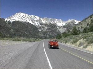
The Amateur Traveler talks to Doug McConnell of OpenRoad.tv (formerly on Bay Area Backroads) about his love for the Eastern Sierra Nevada mountains.
Doug has been going to this rugged, stark and beautiful area of California and Nevada since he was a kid. He tells us about Hollywood’s love of this area, the oldest trees on the planet, the water wars of California, the tufa fields of Mono Lake, the ghost town of Bodie and more.
He also tells of his friends Galen and Barbara Rowell who called this area their home until their deaths in 2002. Galen was a renowned nature photographer and Barbara was his partner and pilot.
![]()
click here to download (mp3)
click here to download (iTunes enhanced version with pictures)
News
Travel News – Top 10 American Sites, Top 10 American Parks, Stupid Tourist Questions, Fool Fell, Tail Bumped
- America’s top 10 tourist attractions
- 20 stupid questions asked by tourists
- Tourist falls from St. Pete Beach hotel balcony
Show Notes
William Mulholland
California Water Wars
Lone Pine Film History Museum
Lone Pine Film Festival
Manzanar National Historic Site
Mountain Light Gallery
Galen Rowell
Barbara Rowell
Rowell Award for Art of Adventure
Alabama Hills
Internet Resources
Mapness.net – create a map for your trip
Community
Lonely Planet Blog Award Winners (not me)
Thanks for your support
Nicole discovers her home state of Maine
 21 Best Things to Do in the Sierra Nevada Mountains
 Travel to Lake Tahoe in Nevada and California – Episode 298
 Las Vegas, Nevada – Episode 47
 Travel to Las Vegas, Nevada – Episode 338
by Chris Christensen
Chris Christensen is the creator of the Amateur Traveler blog and podcast. He has been a travel creator since 2005 and has won awards including being named the "Best Independent Travel Journalist" by Travel+Leisure Magazine.+Chris Christensen | @chris2x | facebook
5 Responses to “Travel to the Eastern Slope of the Sierra Nevada Mountains – Episode 178”
Leave a Reply
Tags: audio travel podcast, california, nevada, podcast


yachtcharter griechenland
Says:April 9th, 2009 at 4:36 am
I was just thinking about Travel to the Eastern Slope of the Sierra Nevada Mountains – Episode and you’ve really helped out. Thanks!
Pam
Says:April 11th, 2009 at 2:33 pm
I just added your program to my list of podcasts, and was so pleased that the first one I listened to was about this area! We just visited there 2 weeks ago, and the descriptions were very accurate. The contrast between the valley and the upper elevations is remarkable. Our son lives in Mammoth Lakes so we spent a week in and around there, from Bishop to Reno on 395. If you want to take a step back in time, stop for lunch at Tom’s Place, between Mammoth and Bishop. It hasn’t changed much in 32 years!
chris2x
Says:April 12th, 2009 at 8:58 am
Thanks Pam. And what should we order from the menu at Tom’s Place?
Brad W
Says:August 25th, 2009 at 1:50 pm
I have enjoyed watching Doug’s “Bay Area Backroads” for years, and am really saddened to hear it’s no longer in production. Glad to know he’s got a new project brewing: I saw it advertised at the end of some recent shows, but hadn’t had a chance to check it out yet.
My experience with 395 was completely by accident. In the mid-90’s, I was camping with my roommate and her sister (a park ranger) in Yosemite at White Wolf when one of the really big fires broke out in the west end of the park. We got the order to evacuate the campground at 4am. (Have you ever tried waking people up at 4am and tell them they have 30 minutes to pack and get out? Can you say “Happy Campers!”?). The only way out was over Tioga Pass, then north on 395.
It was absolutely gorgeous. I have many wonderful memories from the road that day. Even though spots were windy, it was still breathtaking scenery. As a Central Californian, it’s way too easy to fall into the 41/120/140 rut to race back home in time for work on Monday. I had never appreciated what lies just on the other side of those hills.
Hats off for an interesting episode.
Fred Lusk
Says:May 9th, 2011 at 11:45 pm
I really enjoyed this postcast. Doug obviously knows and loves the Eastern Sierra. Even though my favorite places in the Sierra Nevada are on the west slope (Yosemite, in particular), the east slope/Owens Valley is also incredible.
I would like to add the following, starting south of Lone Pine then working my way north following Doug’s route:
1. About 40 miles south of Lone Pine, right along the east side of Hwy 395, is Fossil Falls. This is a dry waterfall about 40 feet tall that was created during the last ice age, when Owens Lake was larger and overflowed to the south. Wikipedia has a decent article (http://en.wikipedia.org/wiki/Fossil_Falls) that also mentions nearby Red Hill and Little Lake.
2. If you’re coming this way via the San Joaquin Valley and Bakersfield/Tehachapi/Mojave (Hwys 99, 58, and 14), Red Rock Canyon State Park along Hwy 14 is worth a stop to look at the geology. There is also a campground. Red Rock Canyon straddles Hwy 14 about 20 miles north of Mojave. From there it’s another 35 miles to Fossil Falls.
3. Between Fossil Falls and Lone Pine, Hwy 395 runs along the western “shore” of Owens Lake. There is usually very little water in the lake and when it gets windy a lot of dust blows off the lake bed. Be cautious driving through here when it’s windy.
4. Be sure to stop at the Eastern Sierra Interagency Visitor Center at the junction of Hwy 395 and Hwy 136, about 2 miles south of Lone Pine. This is a very good facility and it offers outstanding views of the highest portion of the Sierra Crest, including Mt. Whitney and several other 14’ers.
5. As an aside, from 1971 through 1981, the little town of Lone Pine hosted a series of 11 international chess tournaments (http://en.wikipedia.org/wiki/Lone_Pine_International).
6. The 1872 Owens Valley Earthquake virtually destroyed Lone Pine. A section of the fault scarp can be seen at http://www.its.caltech.edu/~meltzner/owens/
7. Manzanar National Historical Site (10 miles north of Lone Pine) is well worth a stop, but be aware that almost all of the camp has been torn down. See http://www.nps.gov/manz/index.htm for more info.
8. Independence, about 15 miles north of Lone Pine, has the Eastern California Museum and Inyo County’s courthouse.
9. The road to the White Mountains (Hwy 168) branches east off of Hwy 395 at Big Pine. Where the highway squeezes through Westgard Pass, it narrows to one lane for a while (I seem to recall this stretch is several hundred yards long). This is the only one-lane state highway I am aware of.
10. A couple miles northeast of Big Pine is a group of radio telescopes (dishes) owned by Caltech. I have seen the dishes froma distance. I don’t think the site can be visited.
11. There are two main bristlecone pine groves in the White Mountains: Shulman Grove (10,000′ elevation and site of the visitor center) and Patriarch Grove (11,000′ elevation). The paved road ends at Shulman Grove. From there it’s about 12 miles north along a graded dirt road to Patriarch Grove. Both groves are worth visiting. Patriach Grove is the more “other worldly” of the two. There are several good viewpoints for looking west toward the Sierra Nevada Mountains, including Sierra View Overlook south of Shulman Grove. About 5 miles north of Patriarch Grove is the University of California’s Mt. Barcroft Laboratory (12,400′ elevation). The Barcroft Station conducts high elevation research (bats, bugs, humans, etc). It is open to the public one day each year (currently the first Sunday in August). When we visited about 10 years ago, we got lucky. It just so happened that the day we had planned for the White Mountains was the one day that year the lab was open. Be aware that these sites are at high elevation (less oxygen for humans and automobiles, stronger sun rays). The plateau above the lab (12,800′ elevation) was the runner-up site for the Keck Telescopes that were built on Mauna Kea on Hawaii. When you crest the south edge of the plateau, you can see White Mountain Peak (14,246′) about four miles further north. It can be hiked, but not by me. 🙂 The edge of the plateau was enough. Also be aware that there is no food, water, or gasoline available in this area. Silver Canyon offers an interesting alternative route back to Bishop. It is a steep graded road (drops 6000′ in six miles) best suited to short wheelbase vehicles. High clearance and 4WD with low range are useful, but I did see one sedan ahead of us do OK, though his brakes smelled. Some of the hairpins are so tight that I was doing 3- and 5-point turns in my 4WD Jeep Cherokee.
12. Mammoth Lakes/Mammoth Mountain is part of the Long Valley Caldera complex. Long Valley is one of the largest volcanic calderas on earth (http://en.wikipedia.org/wiki/Long_Valley_Caldera). There are hot springs and cinder cones in the area, regular minor to moderate earthquakes, outgassing, etc. It is also a beautiful area. The town of Mammoth Lakes is also the gateway to Devil’s Postpile National Monument, which actually sits WEST of the Sierra crest. Access by private vehicle is resticted (most people go in by bus), At the very least, stop at Minaret Summit for an incredible view.
That’s probably enough. If you’re a member of AAA, I strongly suggest getting a copy of their “Guide to the Eastern Sierra.” It has maps and lists of sites, etc. for the area from Lone Pine to Bridgeport.
Have fun!